Skip to content

Brandon Karcher

Coliform Trends in Urban Streams receiving Stormwater within Lycoming County MS4

The Clean Water Institute at Lycoming College has been conducting field and laboratory analysis on the urban streams of Lycoming County MS4 region since 2015. The County MS4 includes 9 municipalities/boroughs. Over 200 stormwater outfalls empty into 8 urban streams (Grafius Run, McClure Run, Millers Run, Bull Run, Mill Creek, Tules Run, Mosquito Creek and Hagermans Run) plus Lycoming Creek, Loyalsock Creek and the West Branch Susquehanna River. Quarterly and in some cases monthly samples for chemical analysis ( pH, alkalinity, temperature, dissolved Oxygen (DO), conductivity, Total Dissolved Solids(TDS), nitrite, nitrate, orthophosphate, total phosphorus ) as well as coliforms have been collected from 1-3 sites within 8 urban streams for two years. Membrane filtration was specifically carried out on the water samples to identify the presence of E.coli in them. Fecal contamination may be an indicator of sewage input. This paper provides the trend in coliform count over the years since 2017. The examination of data trends serve as a baseline to be used to implement projects that seek to improve the water quality of the urban streams of Lycoming County MS4 region.

Factors related to recreational visit frequency to freshwater ‘blue space’ in Pennsylvania: the role of restoration and associations with perceived stress

Spending time in areas with aquatic features (‘blue space’) may benefit health through ‘restoration’ from attentional fatigue and emotional stress. Salutogenic effects of blue space remain underexplored, particularly in non-coastal and non-urban areas, as do correlates of visit frequency to freshwater blue space (FBS). We surveyed adults in 40 small towns in central/northeast Pennsylvania to understand their seasonal visitation patterns to FBS, characteristics that predict visit frequency, and associations between FBS visit frequency and perceived stress. Of 10,000 mailed questionnaires, 1,122 individuals (11%) responded and provided information to characterize FBS visit frequency. Perceived stress was evaluated with a scale of 10 items regarding stressful feelings in the past month. A restoration outcomes scale from FBS was calculated for respondents who reported visiting FBS (n=868). Analyses included multivariate multinomial regression to examine predictors of FBS visit frequency and linear regression to evaluate FBS visit frequency in association with perceived stress, using mixed effects models with a random effect for town of residence to account for spatial clustering. Nearly one-fifth (19%) of respondents reported never visiting FBS, 27% had low visit frequency (1-3 days/season), 35% moderate frequency (4-15 days/season), and 19% high frequency ( 16 days/season). Higher education was associated with more frequent blue space visits across all categories of visit frequency. Greater physical activity and living closer to FBS access points were associated with moderate and high visit frequency. High restoration was associated with greater visit frequency among those who visited FBS. Individuals who experienced high restoration were more likely to report the presence of nature as important in enhancing visits to FBS and stress relief as the most important benefit of FBS visits. FBS visit frequency was not associated with perceived stress. Findings highlight the socioeconomic patterning of FBS visits, the importance of access to facilitate visits, and perceived psychological benefits to FBS visits among the most frequent visitors.

Role of Constructed Stormwater Detention Ponds vs Natural Systems in Mitigating Flooding from a Suburban University Campus in Southwest Florida

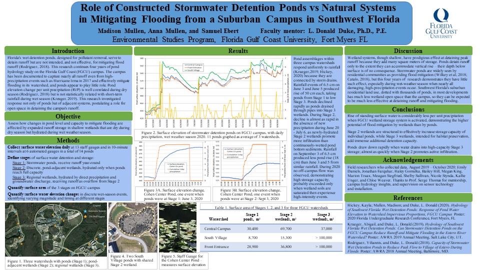
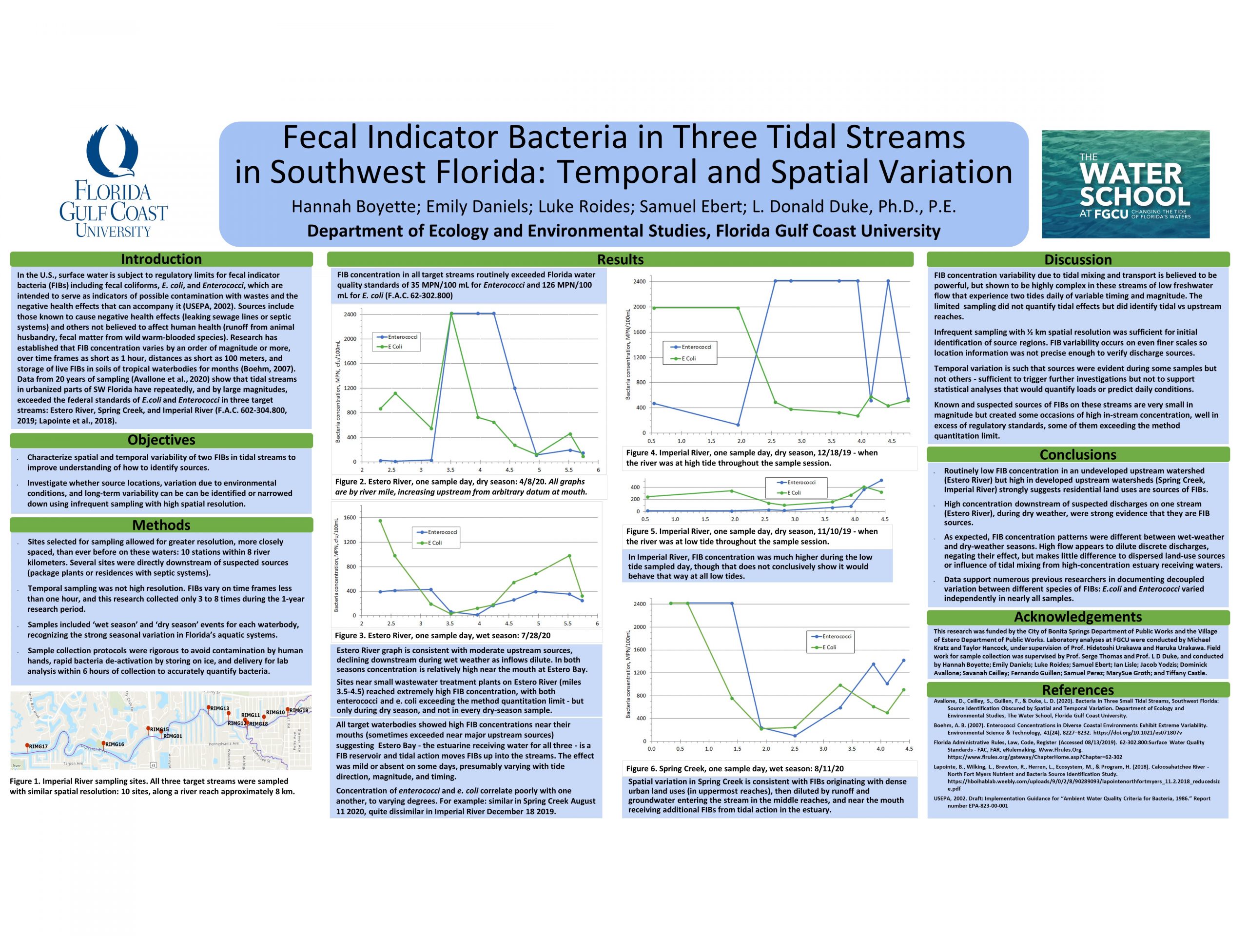
Florida regulations require residential and commercial developments to install stormwater detention ponds, for the purpose of reducing nutrient pollutants in runoff to receiving waters. The 800-acre main campus of Florida Gulf Coast University (FGCU), in southwest Florida, mitigates flooding not only with its ponds – 15 designed ponds, of an aggregate 17 acres – but with its 400 acres of open space, most of which contain functioning wetlands.
Stormwater ponds are widely seen by residential communities as providing flood mitigation (Catalo and Duke, 2018), but that is not a stated regulatory purpose and not an appreciable effect: previous research on FGCU ponds quantified a consistent elevation change with rainfall magnitude after dry-season storms (Rodriguez and Duke 2018) but no correlation with short-term precipitation during the wet season, when nearly all of southwest Florida’s potentially-damaging, high-precipitation events occur (Krueger and Duke 2019). This present research continues investigation of surface water elevation and precipitation, adding to the 4-year record of 24-hour interval data with automated sensors collecting data on 10-minute intervals. Quantitative results demonstrate the campus surface water responds differently during each of three stages. During Stage 1, encompassing the dry weather season, most runoff enters the 17 acres of ponds, which have enough capacity to capture all runoff from impervious surfaces. The campus enters Stage 2 when ponds spill over into adjacent wetlands, nearly tripling surface area and vastly increasing capacity to detain runoff: elevation per unit rainfall rose less than half as far as during a comparable rainfall event during dry season. When precipitation ceased, surface elevation declined rapidly during Stage 2, hypothesized to be driven by sorption into newly-hydrated soils and enhanced groundwater recharge from increased wetted surface area. Stage 3 is infrequently activated – when precipitation occurs atop standing water in Stage 2 – and storage increases another order of magnitude as constructed drains direct flow into nearly 300 acres of Stage 3 wetlands. Discharge from the campus, which occupies the top of the Estero River watershed, occurs only when intense precipitation occurs atop fully saturated, high-elevation Stage 3 conditions, as in Hurricane Irma in 2017; essentially zero water left campus during wet seasons in 2019 and 2020. Conclusions are
that surface water elevation rises considerably more per unit precipitation when only FGCU’s ponds are capturing runoff, and less when the wetland storage system is activated. Flooding is mitigated much more effectively by the wetlands than by stormwater detention ponds, as Stage 2 wetland geometry in effect increases storage capacity of individual ponds, while Stage 3 wetlands, intended for habitat preservation, add immense additional detention capacity. The wetlands also produce more rapid water level decline than ponds, so they recover to pre-flood capacity much more quickly than a system of ponds alone.
The research’s broader implications are that wetland systems, though shallow, have a prodigious effect at detaining peak runoff, because storage capacity is dominated by surface area rather than depth: ponds detain runoff only to the extent they can accommodate vertical rise, and their depth below surface is of no consequence. Southwest Florida’s suburban residential land use, dotted with thousands of ponds, in most developments have very little wetland open space (Wilkey et al, 2018), and consequently limited capacity to detain runoff and mitigate flooding.

How a Karst Watershed Swallowed Half of the Excess Rainfall in Its Wettest Year Ever

63.75 inches of rainfall and snowmelt water made 2018 the wettest year in 122 years of record for the Spring Creek Watershed in Centre County, PA. Yet it experienced very limited overbank stream flooding even though its 30-year average annual precipitation of 40.66 inches was exceeded by 57%. This presentation will explain how the unique combination of its hydrogeologic characteristics enabled this karst watershed to convert the excess rainfall into stored groundwater recharge instead of floodwater runoff. Much of the storm-water runoff from the watershed’s surrounding mountain ridges flowed into sinkholes at the base of the ridges and was directly converted into groundwater recharge, thereby mitigating storm-water flooding. You will learn the details of how this watershed’s unique carbonate flow systems took in and stored 38 billion gallons of groundwater recharge from the 70 billion gallons of above-normal precipitation for a capture ratio of 55%.

Ecological Vitality: The Critical Third Leg of Sustainability @ Bucknell

Sustainability @ Bucknell praxis can be viewed in multidimensions with three critical legs on the tripod of both short- and longer-term resiliency and endurance of the campus community. These three legs are waste reduction, decarbonization and ecological vitality. Ecological vitality deals with natural habitat diversity and overall balance through effective conservation, restoration and protection. These three legs of sustainability are both interrelated and interdependent. An effective management for ecological vitality will results in both waste reduction and decarbonization. Each leg of the sustainability tripod require effective management, leadership and governance processes. At Bucknell, these processes are driven by key stakeholder groups beginning with the Environmental, Social and Governance (ESG) Subcommittee of the Board of Trustees (BOT) to the individual students, faculty, staff and the larger local-to-global Bucknell community. The paper presents the structural and process mechanisms established and implemented to ensure Bucknell’s journey towards ecological vitality through conversation and restoration.

Sustainability at Bucknell: A Local-to-Global Riverfront Learning Community

Sustainability is the ability of a community to endure and remain resilient socially, technologically and environmentally. At the most local level, a community is a collection of families and globally, a collection of nations. On this local-to-global continuum are institutions, corporations and political units such as states, counties, cities and townships. Governance processes in these communities must recognize contemporary challenges and constraints to deploy appropriate technologies and build infrastructure for local resilience and endurance with global equity. As a community, Bucknell University Strategic Plan for 2025 stipulates the establishment and implementation of an environmental sustainability plan. This paper presents the process of simultaneously developing and implementing the sustainability plan through four transdisciplinary and cross-functional working groups of students, faculty and staff.

Wolf Run Restoration Project: Continuation of Monitoring Four Farms Completing BMP’s in Partnership With Lycoming County Conservation District.

The aim of this study is to look at density and diversity of fish surveys since the institution of the Total Maximum Daily Load (TMDL) for Wolf Run watershed. The TMDL was developed in 2002 because of major impairments seen. Since then, the TMDL has been completed in 2013 by Pennsylvania DEP. In 2015 the Lycoming County Conservation District identified four farm sites for participation in Best Management Practices (BMP) and yearly evaluation. The Clean Water Institute interns this summer were tasked with helping complete the annual fish surveys for the four farm sites. In addition to the fish survey, monthly water chemistry and coliform samplings were collected. Then, the macroinvertebrate samples were completed in October 2020. The fish surveys have been collected since 2017, a year before the project was completed for a base survey. Interpretation of the fish surveys was completed through a program called MicroFish and the Shannon-Weiner Diversity Index. The density of fish found at farm sites 2-4 have gone up an average of 1000 fish per kilometer. The one exception being site 1 (Artley Farm), which saw a slight decrease. The diversity index shows a consistent trend, with some minor fluctuations. Furthermore, an Index of Biological Integrity shows that none of the sites are impaired biologically and are improving since the input of the BMP’s. Site 3 (Fry Farm) is still close to impairment, but is continuing to improve annually. By 2025 it is predicted that these sites will no longer be impaired, and the levels of nitrogen, phosphorus, and sediment will be extensively lowered with an increase in diversity and density. Finally, Lycoming College CWI will continue to partner and assist on this project.

Conservation genomics of Pennsylvania-threatened Baptisia australis var. australis: an investigation in riparian gene flow

The perennial wildflower, Baptisia australis var. australis (L.) R. Br. is found along only four waterways in Pennsylvania: the Allegheny River, Youghiogheny River, Clarion River, and Red Bank Creek. Because of its limited distribution and small number of extant populations, B. australis var. australis is considered state-threatened in Pennsylvania. In addition, the riparian prairie habitat that Pennsylvania Baptisia australis var. australis is restricted to is also in decline and considered vulnerable in the state. Because of conservation concerns for Baptisia australis var. australis in Pennsylvania, gaining insights into the natural history and genetics of the taxon is useful for conservation practitioners. This project seeks to determine the genetic structure and health of known native populations and apply that information to understanding riparian gene flow, as well as establishing conservation units. Genotyping-by-sequencing (GBS) was used to collect genomic data for use in population genetics analyses. My work synthesizes these data to gain insight into the metapopulation dynamics of this riparian system and examine patterns of gene flow. We found that there are three genetic groups of Baptisia australis var. australis in Pennsylvania, with one of these showing internal genetic structure. This finding can be applied to management units for the taxon. Some Pennsylvania populations are becoming increasingly isolated as well as dwindling in population size, making now an ideal time to collect seeds and facilitate gene flow while levels of inbreeding are relatively low. My research will inform the conservation status of Baptisia australis var. australis in Pennsylvania, as well as clarify lingering uncertainties about gene flow in riparian plant populations.

Watershed Awareness using Technology and Environmental Research for Sustainability (WATERS)

The Watershed Awareness using Technology and Environmental Research for Sustainability (WATERS) project funded by NSF develops and researches a student-centered, universally accessible curriculum for teaching water concepts & career awareness. Applying Universal Design for Learning (UDL) principles, the project increases awareness of and engagement with water concepts and career pathways for more learners.

Fecal Indicator Bacteria in Three Tidal Streams in Southwest Florida: Temporal and Spatial Variation

In the U.S., surface water is subject to regulatory limits for fecal indicator bacteria (FIBs) including fecal coliforms, e. coli, and Enterococci, which serve as indicators of possible contamination with human wastes and the negative health effects that can accompany it. Data from 20 years of sampling show that, among other waterbodies, tidal streams in urbanized parts of Southwest Florida have repeatedly, and by large magnitudes, exceeded the federal standards for both Enterococci (30 MPN/100mL geometric mean [GM] and 130 MPN/100mL Ten Percent Threshold Value [TPTV]) and e. coli (70 MPN/100mL GM and 410 MPN/100mL TPTV) in three target streams: Estero River, Spring Creek, and Imperial River.
The objective of this study was to characterize the spatial and temporal variations of Enterococci and e. coli in target waterbodies, and with the aim of identifying possible source locations. This research conducted a small number of sample events (3 to 8 times over one year) on a fine spatial resolution (more than one sample per linear kilometer on three 8-km stream reaches. Results were, as expected, not able to identify or compensate for variations – especially varying tides, flows, storm events, and human activities – but showed surprisingly strong ability to document differing pollutant tendencies in different portions of each reach. Upstream reaches of Estero River extending beyond residential development routinely showed very small FIB concentration while upstream reaches of Spring Creek and Imperial River, more densely developed, routinely had very high FIB concentration, documenting that human land use affects FIBs more powerfully than other potential sources (sediments, soils, non-human animals, etc.). Two reaches of Estero River near privately-operated small wastewater treatment plants showed higher concentrations in nearly every sample, documenting those as sources of particular concern. In all three streams FIBs were in high concentration near the mouth, suggesting that resuspension of estuarine sediments and/or inland movement of estuarine waters influence bacteria concentrations, a mechanism for future research to target.